
ISBN: 9781566954693
Forest Service and others, this expertly researched map features key areas of interest such as Bowman Lake, Lake McDonald Valley, Goat Haunt and Avalanche Creek. Every Trails Illustrated … Mehr…
| ebay.de superbookdeals1 95.0, Zahlungsarten: APPLE_PAY, Paypal, Google Pay, Visa, Mastercard, American Express, Priority Listing. Versandkosten:Versand zum Fixpreis, [SHT: Standardversand], DE74 *** Castle Donington, [TO: Weltweit] (EUR 6.40) Details... |

North Fork, Glacier National Park: Trails Illustrated National Parks (National Geographic Trails Illustrated Map, Band 313) - gebrauchtes Buch
2012, ISBN: 9781566954693
National Geographic Maps, Landkarte, Auflage: 2009th ed, 1 Seiten, Publiziert: 2012-08-02T00:00:01Z, Produktgruppe: Book, Hersteller-Nr.: TI00000313, 0.21 kg, Verkaufsrang: 39311, Atlante… Mehr…
| amazon.de buchhandlung-barz Gebraucht, wie neu. Versandkosten:Auf Lager. Die angegebenen Versandkosten können von den tatsächlichen Kosten abweichen. (EUR 3.00) Details... |

2012, ISBN: 9781566954693
Erscheinungsdatum: 02.08.2012, Medium: (Land-)Karte, Titel: North Fork, Glacier National Park, Titelzusatz: Trails Illustrated National Parks, Auflage: 2009th ed, Autor: Maps, National Ge… Mehr…
| Averdo.com Nr. 78841188. Versandkosten:, Next Day, DE. (EUR 0.00) Details... |

2012, ISBN: 9781566954693
Trails Illustrated National Parks, Karte/Globus, Karte (gefalzt), 2021st ed. [PU: National Geographic Maps], National Geographic Maps, 2012
| lehmanns.de Versandkosten:Versand in 7-10 Tagen. (EUR 0.00) Details... |

2012, ISBN: 156695469X
2009th ed. Kartoniert / Broschiert, mit Schutzumschlag neu, [PU:National Geographic Maps]
| Achtung-Buecher.de MARZIES.de Buch- und Medienhandel, 14621 Schönwalde-Glien Versandkosten:Versandkosten innerhalb der BRD. (EUR 1.95) Details... |


ISBN: 9781566954693
Forest Service and others, this expertly researched map features key areas of interest such as Bowman Lake, Lake McDonald Valley, Goat Haunt and Avalanche Creek. Every Trails Illustrated … Mehr…


Maps, National Geographic:
North Fork, Glacier National Park: Trails Illustrated National Parks (National Geographic Trails Illustrated Map, Band 313) - gebrauchtes Buch2012, ISBN: 9781566954693
National Geographic Maps, Landkarte, Auflage: 2009th ed, 1 Seiten, Publiziert: 2012-08-02T00:00:01Z, Produktgruppe: Book, Hersteller-Nr.: TI00000313, 0.21 kg, Verkaufsrang: 39311, Atlante… Mehr…

2012
ISBN: 9781566954693
Erscheinungsdatum: 02.08.2012, Medium: (Land-)Karte, Titel: North Fork, Glacier National Park, Titelzusatz: Trails Illustrated National Parks, Auflage: 2009th ed, Autor: Maps, National Ge… Mehr…
2012, ISBN: 9781566954693
Trails Illustrated National Parks, Karte/Globus, Karte (gefalzt), 2021st ed. [PU: National Geographic Maps], National Geographic Maps, 2012
2012, ISBN: 156695469X
2009th ed. Kartoniert / Broschiert, mit Schutzumschlag neu, [PU:National Geographic Maps]
Bibliographische Daten des bestpassenden Buches

| Autor: | |
| Titel: | |
| ISBN-Nummer: |
• Waterproof • Tear-Resistant • Topographic Map
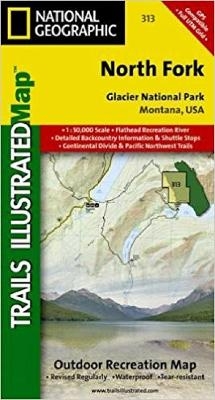
National Geographic's Trails Illustrated map of North Fork in Glacier National Park will benefit even the most experienced outdoors enthusiast, as you explore this pristine landscape that has very few amenities. Two additional maps for Many Glacier and the Two Medicine regions of the park along with a comprehensive Glacier National Park Trails Illustrated map are also available.Created in partnership with the National Park Service, U.S. Forest Service and others, this expertly researched map features key areas of interest such as Bowman Lake, Lake McDonald Valley, Goat Haunt and Avalanche Creek.
The North Fork map is an invaluable resource for exploring the mapped trails of the area, including the Pacific Northwest Trail, the Continental Divide Trail and recommended biking trails. The map base includes contour lines and elevations for summits, passes and major lakes. Charts of unbridged stream crossings as well as seasonal plank and suspension bridges will also aid in your navigation of the area. Recreation features are clearly marked, including campgrounds, backcountry campsites, trailheads, interpretive trails, fishing and boat access and horse rental locations. A variety of helpful information about recreation activities available in the park, backcountry hiking and camping, regulations, and safety tips is included as well.
Every Trails Illustrated map is printed on "Backcountry Tough" waterproof, tear-resistant paper. A full UTM grid is printed on the map to aid with GPS navigation.
Other features found on this map include: Apgar Mountains, Bowman Lake, Flathead National Forest, Glacier, Kintla Lake, Lake McDonald, Lewis Range, Livingston Range, Mount Carter, Mount Cleveland.
Map Scale = 1:50,000Sheet Size = 37.75" x 25.5"Folded Size = 4" x 7.5"Detailangaben zum Buch - North Fork, Glacier National Park
EAN (ISBN-13): 9781566954693
ISBN (ISBN-10): 156695469X
Gebundene Ausgabe
Erscheinungsjahr: 2009
Herausgeber: National Geographic Maps
2 Seiten
Gewicht: 0,091 kg
Sprache: eng/Englisch
Buch in der Datenbank seit 2012-09-05T09:38:06+02:00 (Berlin)
Detailseite zuletzt geändert am 2022-08-28T18:36:50+02:00 (Berlin)
ISBN/EAN: 9781566954693
ISBN - alternative Schreibweisen:
1-56695-469-X, 978-1-56695-469-3
Alternative Schreibweisen und verwandte Suchbegriffe:
Autor des Buches: national geographic maps
Titel des Buches: park, 313, national north, montana map, best national geographic, fork fork
Weitere, andere Bücher, die diesem Buch sehr ähnlich sein könnten:
Neuestes ähnliches Buch:
9781566953184 Glacier/waterton Lakes National Parks (National Geographic Maps)
- 9781566953184 Glacier/waterton Lakes National Parks (National Geographic Maps)
- 9781560443230 Glacier & Waterton Lakes National Parks (Sample, Michael S)
- 9781560447184 Hiking Glacier and Waterton Lakes National Parks (rev) (Erik Molvar)
- 9780762736331 Best Easy Day Hikes Glacier and Waterton Lakes National Parks (Erik Molvar)
< zum Archiv...