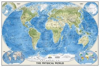
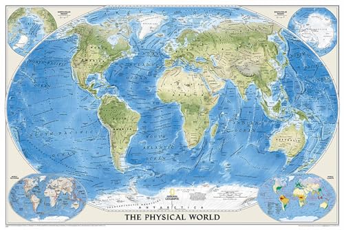
Wall Maps World, Karte/Globus, Karte (gerollt), 2016th ed. National Geographic's The Physical World map highlights the Earth's land and undersea forms with exquisite hand-painted relief. … Mehr…
Wall Maps World, Karte/Globus, Karte (gerollt), 2016th ed. National Geographic's The Physical World map highlights the Earth's land and undersea forms with exquisite hand-painted relief. Drawn in the Winkel Tripel projection to minimise distortion of the landforms. Two corner inset maps show the Earth's crust and world climatic zones. Enlarged size. Scale: 1:24,031,000. Tubed. 175 x 122 cm. [PU: National Geographic Maps], National Geographic Maps, 2012<
lehmanns.de
Versandkosten:Titel z.Zt. nicht lieferbar. (EUR 0.00) Details...
(*) Derzeit vergriffen bedeutet, dass dieser Titel momentan auf keiner der angeschlossenen Plattform verfügbar ist.
NEW! Ships NOW, ROLLED in a sturdy mailing tube! -71" x 48" paper NGS physical MAPS4U from the shelves of Wide World Maps & MORE! -Ask us about upgrading to a laminated, school roller, or… Mehr…
NEW! Ships NOW, ROLLED in a sturdy mailing tube! -71" x 48" paper NGS physical MAPS4U from the shelves of Wide World Maps & MORE! -Ask us about upgrading to a laminated, school roller, or framed version!, Neubuch, [PU: National Geographic Society]<
alibris.co.uk
Phoenix, AZ, Wide World Maps & More Versandkosten:zzgl. Versandkosten Details...
(*) Derzeit vergriffen bedeutet, dass dieser Titel momentan auf keiner der angeschlossenen Plattform verfügbar ist.
National Geographic Maps - Reference: National Geographic: World Physical Enlarged Wall Map (69.25 x 46.25 inches) (National Geographic Re - neues Buch
Wall Maps World, Karte/Globus, Karte (gerollt), 2016th ed. National Geographic's The Physical World map highlights the Earth's land and undersea forms with exquisite hand-painted relief. … Mehr…
Wall Maps World, Karte/Globus, Karte (gerollt), 2016th ed. National Geographic's The Physical World map highlights the Earth's land and undersea forms with exquisite hand-painted relief. Drawn in the Winkel Tripel projection to minimise distortion of the landforms. Two corner inset maps show the Earth's crust and world climatic zones. Enlarged size. Scale: 1:24,031,000. Tubed. 175 x 122 cm. [PU: National Geographic Maps], National Geographic Maps, 2012<
Versandkosten:Titel z.Zt. nicht lieferbar. (EUR 0.00)
NEW! Ships NOW, ROLLED in a sturdy mailing tube! -71" x 48" paper NGS physical MAPS4U from the shelves of Wide World Maps & MORE! -Ask us about upgrading to a laminated, school roller, or… Mehr…
NEW! Ships NOW, ROLLED in a sturdy mailing tube! -71" x 48" paper NGS physical MAPS4U from the shelves of Wide World Maps & MORE! -Ask us about upgrading to a laminated, school roller, or framed version!, Neubuch, [PU: National Geographic Society]<
Versandkosten:zzgl. Versandkosten Phoenix, AZ, Wide World Maps & More
National Geographic Maps - Reference: National Geographic: World Physical Enlarged Wall Map (69.25 x 46.25 inches) (National Geographic Re - neues Buch
1Da einige Plattformen keine Versandkonditionen übermitteln und diese vom Lieferland, dem Einkaufspreis, dem Gewicht und der Größe des Artikels, einer möglichen Mitgliedschaft der Plattform, einer direkten Lieferung durch die Plattform oder über einen Drittanbieter (Marketplace), etc. abhängig sein können, ist es möglich, dass die von eurobuch angegebenen Versandkosten nicht mit denen der anbietenden Plattform übereinstimmen.
Detailangaben zum Buch - World Physical, Enlarged &, Tubed
EAN (ISBN-13): 9780792280897 ISBN (ISBN-10): 079228089X Gebundene Ausgabe Erscheinungsjahr: 2007 Herausgeber: National Geographic Maps Gewicht: 0,398 kg Sprache: Englisch
Buch in der Datenbank seit 2008-03-24T21:30:15+01:00 (Berlin) Detailseite zuletzt geändert am 2023-07-06T20:35:23+02:00 (Berlin) ISBN/EAN: 079228089X
ISBN - alternative Schreibweisen: 0-7922-8089-X, 978-0-7922-8089-7 Alternative Schreibweisen und verwandte Suchbegriffe: Autor des Buches: national geographic Titel des Buches: best national geographic, maps, world physical, map the world